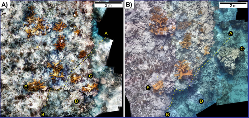
Perhaps the most important feature of video mosaic surveys is that they create a high resolution baseline image of your study site at the time of surveying. The Elkhorn coral (Acropora palmata) study site (below) was surveyed initially in May 2005 as a means to document one of the few remaining populations of this threatened species in the Florida Keys. However due to the passage of 4 major storms the following summer (Hurricanes Dennis, Katrina, Rita and Wilma) the initial image was then used as a means to assess the impacts of these storms on this Elkhorn coral population.

Figure 1 The mosaic image shown in (A) was acquired at Molasses Reef in the Florida Keys in May 2005. The image shown in (B) shows the same area in February 2006 after the passage of 4 hurricanes.
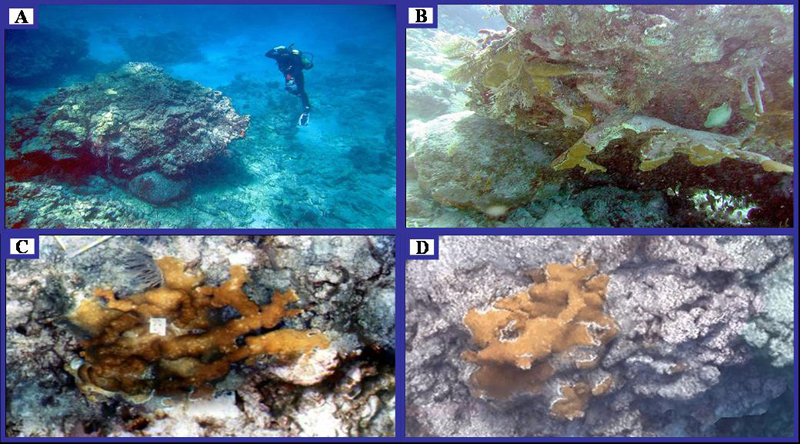
The second mosaic survey in February 2006 showed significant changes to the reef framework and individual coral colonies. The area above in (A) delineated as line B-A indicates the area of reef framework that was dislodged during Hurricane Dennis. Images of the broken piece of reef and the effects of these hurricanes on individual elkhorn colonies are shown below. The mosaic images were also used to measure coral colonies before and after the hurricanes for direct damage assessment. Full details of this study can be found in (Gleason et al, 2007).

Figure 2: (A) indicates the relative size of the reef framework that was dislodged during the 2005 hurricane season. (B) shows a close-up image of the Elkhorn coral colonies that were eventually lost due to the beakage of the reef framework in A. (C) and (D) show close up images of a signle elkhorn coral colony in May 2005 and again in February 2006. In this case the passage of the major storms resulted in the breakage and removal of many arms of the coral colony resulting in significantly less live coral tissue.
These images show the true strength of mosaic monitoring surveys. Because it is impossible to predict when a hurricane, bleaching or disease event may occur it is imperative to have extensive baseline information from your study area from which to make accurate impact assessments. Mosaics provide users with the opportunity to document the health of hundreds of coral colonies in a short period of time without the use of tagging. They also provide large high resolution images that help to communicate what is happening on present day reefs to both the scientific community and the public at large.
Publication:
Gleason, A.C., Lirman, D., Williams, D., Gracias, N.R., Gintert, B.E., Madjidi, H., Reid, R.P., Boynton, G.C., Negahdaripour, S., Miller, M. and Kramer, P. (2007) Documenting hurricane impacts on coral reefs using two-dimensional video-mosaic technology. Marine Ecology 28:1-5.


