FAQ

GET STARTED
1
Request Info
2
Visit
3
Apply

Frequently Asked Questions (FAQ)

Accordion Group

Open All Tabs
  • What is a landscape mosaic?

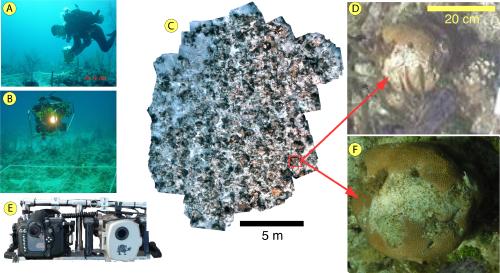
    Individual underwater images taken close to the seabed (~1-2m) have high resolution and minimal water column attenuation, but cover only a small area. A landscape mosaic is a composite of many underwater images. The mosaics have the clarity and resolution of individual pictures but afford a "landscape view" of the seabed (Fig 1).

    The U.S. Strategic Environmental Research and Development Program (SERDP) has supported a) the development of software tools for generating underwater landscape mosaics without relying on external navigation and b) the evaluation of these mosaics for coral reef mapping and monitoring. We are seeking to identify potential applications and partners who might take advantage of this unique new data source.

    fact sheet
    Figure 1: Mosaic overview: Video images acquired by a diver (A) or other platform such as an ROV (B) are automatically stitched together to form a landscape mosaic (C) covering a large area (about 100 m2 in this case). "Standard mode" (i.e. video only) produces mosaics with mm-scale resolution (D). In "enhanced mode", still imagery is acquired simultaneously with the video (E) to achieve sub-mm resolution (F).

    Data Acquisition Requirements: Mosaics are made in one of two modes: "Standard mode" uses video data only; "Enhanced mode" uses still images acquired synchronously with the video. Both need:

    Near-nadir view video 1-2 m from seabed. High (~80 percent) overlap between swaths.

    Enhanced mode additionally requires:
    Still camera synchronized with video.

    Mosaic Characteristics:
    Area covered: ~ 400 m^2 (~2000 frames) Spatial resolution (pixel size): sub-mm (in enhanced mode); ~ 3 mm (in standard mode). Spatial accuracy: +/-5 cm (1 standard deviation)

  • How long does it take?

    Data acquisition takes about 20-40 minutes (i.e. one dive), depending on the size of the site to be surveyed. The mosaic production is highly automated, requiring about 4 man-hours and 24-36 hours computer time with current desktop processors.

  • How do landscape mosaics compare with traditional techniques?

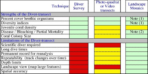
    Mosaics retain key strengths of a diver-based approach, while overcoming the limitations of diver-based or photo-quadrat / video transect methods (Table 1).

    Table 1: Comparison of Monitoring Techniques
    Reid Imaging

    Green indicates full capability, yellow partial capability, and red poor capability. Note (1): Enhanced mode required for species-level IDs, but identification of major functional groups (e.g., corals, sponges, algae) is done with standard mode. Note (2): Enhanced mode required.

  • Data Acquisition Requirements

    Mosaics are made in one of two modes: "Standard mode" uses video data only; "Enhanced mode" uses still images acquired synchronously with the video. Both need:

    • Near-nadir view video 1-2 m from seabed.
    • High (~80 percent) overlap between swaths.

    Enhanced mode additionally requires:
    • Still camera synchronized with video.

  • Mosaic Characteristics

    • Area covered: ~ 400 m^2 (~2000 frames)
    • Spatial resolution (pixel size): sub-mm (in enhanced mode); ~ 3 mm (in standard mode).
    • Spatial accuracy: +/-5 cm (1 standard deviation)

  • How long does it take?

    Data acquisition takes about 20-40 minutes (i.e. one dive), depending on the size of the site to be surveyed. The mosaic production is highly automated, requiring about 4 man-hours and 24-36 hours computer time with current desktop processors.

  • How do landscape mosaics compare with traditional techniques?

    Mosaics retain key strengths of a diver-based approach, while overcoming the limitations of diver-based or photo-quadrat / video transect methods (Table 1).

    Table 1: Comparison of Monitoring Techniques

    Green indicates full capability, yellow partial capability, and red poor capability. Note (1): Enhanced mode required for species-level IDs, but identification of major functional groups (e.g., corals, sponges, algae) is done with standard mode. Note (2): Enhanced mode required.


  • What are the advantages of landscape mosaics?

    • Landscape view: Mosaics provide a landscape view of coral reefs that has previously been unobtainable. This enables new measures of reef health, such as documenting spatial relationships of disease patterns, or the effects of hurricane damage and ship groundings.
    • Spatial accuracy: High spatial accuracy, combined with a landscape view, enables accurate size and distance measurements to be taken directly from the mosaic. Mosaics can be georeferenced and integrated with other data sets using Geographic Information Systems (GIS)
    • Colony monitoring without tagging: Mosaics are efficient tools to track patterns of change over time. Mosaics collected in repeat surveys can be referenced to one another with only four permanent markers, allowing monitoring of individual coral colonies without the need for extensive tagging.

    Figure 2: Mosaic of a scar created by a ship grounding on a shallow reef, Florida Keys (depth = 3 m). The dashed line marks the extent of damage. The inset shows this mosaic inserted into Google Earth, illustrating the potential to incorporate mosaics in GIS systems. Groundings are large and cumbersome to survey solely by divers. An image conveys more information about the extent of the damage than measurements of the overall dimensions, especially when viewed by non-technical personnel (e.g. juries).


Top